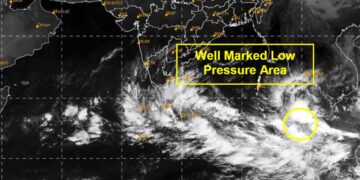


With the Bay of Bengal continuing to churn under intensifying atmospheric conditions, the Indian Meteorological Department has issued a high alert for southern states, including Tamil Nadu, Andhra Pradesh, Kerala, and parts of Karnataka. A deep depression that is forming near the Strait of Malacca is most likely to take the shape of a cyclonic storm, named Cyclone Senyar, within the next 24 to 36 hours, raising concerns about widespread rainfall, strong winds, and potential disruption across coastal regions.
Formation and Path of the Cyclone
According to the latest advisory by IMD, the weather system is now strengthening its circulation while moving west-northwestwards. Forecast models indicate that when the system gains strength and transforms into a named cyclone, it will head towards the southeast Bay of Bengal, gradually veering towards the Andhra–Tamil Nadu coastline. Though predictions of landfall time are fluid, early projections indicate that the system is likely to draw considerably close to the north Tamil Nadu or south Andhra coast by the end of the week.
Meteorologists warned that the system is developing “favourable oceanic and atmospheric conditions,” including sea surface temperatures above 28°C and low vertical wind shear—major preconditions to accelerate the strengthening of any cyclone. If these conditions persist, Cyclone Senyar could develop into a severe cyclonic storm.
IMD Issues Red and Orange Alerts
Heavy to very heavy rainfall is expected and the following alerts have been issued by the IMD:
Red Alert: Coastal Tamil Nadu districts, including Chennai, Chengalpattu, Cuddalore, Nagapattinam, and Villupuram.
Orange Alert: South Andhra Pradesh districts include Nellore, Tirupati, Prakasam, and East Godavari.
Yellow Alert: Parts of Kerala and coastal Karnataka, where moderate to heavy rainfall is likely.
The states have been advised to prepare for heavy rainfall, strong gusty winds likely to cross 60–80 kmph, and rough sea conditions. Fishermen have been strictly cautioned not to venture into the sea for the next few days.
Chennai on High Vigil
Chennai, which has been receiving intermittent rains for a week, braces up for another spell of heavy to very heavy rains. The Greater Chennai Corporation has activated emergency control rooms across the city, and stormwater pumping stations have been put on standby. Several low-lying areas remain prone to flooding, and the civic body is clearing the drains and deploying extra rescue teams.
The city traffic police alerted commuters on possible waterlogging at several critical junctions, while Metro Water officials pre-positioned pumps in readiness against severe inundation in known flood-prone neighbourhoods such as Velachery, Perungudi, MMDA Colony and parts of T. Nagar.
Andhra Pradesh Steps Up Preparations
In Andhra Pradesh, the Chief Minister’s Office instructed the district administrations to stock relief materials and power backup systems at cyclone shelters. The State Disaster Response Force has been mobilized in vulnerable belts, particularly across Nellore and Prakasam districts, which usually bear the brunt of cyclonic disturbances from the Bay of Bengal.
The Andhra Pradesh electricity board, too, has issued advisories warning of power disruptions that may be caused by falling of trees and damage to transmission lines.
Airport, Rail, and Port Operations Under Watch
Airports at Chennai, Tirupati, and Visakhapatnam are closely monitoring the trajectory of the cyclone. Airlines have been advised to keep contingency plans ready for delays or cancellations if the wind speed intensifies during landfall.
All railway zones, including Southern Railway and South Central Railway, have issued alerts to station masters on precautionary measures. Similarly, ports including Chennai Port, Ennore, and Kakinada are likely to declare a temporary suspension of operations if the cyclone intensifies.
Potential Impact and Safety Guidelines
If Cyclone Senyar develops as forecast, the following impacts are possible:
Short-duration urban flooding, particularly in highly populated coastal cities.
Strong winds caused damage to kutcha houses, plantations, and electric poles.
Disruption of power and communication lines.
High waves and storm surge along coastal stretches pose a risk to fisher communities.
The following precautions were urged by authorities to the public:
Avoid peak rainfall hours while traveling.
Stay away from beaches, flooded roads, and open drains.
Charge important devices and ready all emergency kits.
Follow only IMD and official government channels for updates. Conclusion With Cyclone Senyar edging closer to forming in the Bay of Bengal, southern states have been put on high alert for heavy rains and strong winds. While governments have rolled out precautionary measures and rescue teams get ready for quick deployments, the focus, for now, is to limit damage and protect the most vulnerable communities. The next 48 hours will be extremely crucial to ascertain the strength and path of the cyclone, with authorities asking residents to be vigilant and listen to official weather bulletins.


